ZIP Code 5: 84009 - SOUTH JORDAN, UT
ZIP Code 84009 is the postal code in SOUTH JORDAN, UT. Besides the basic information, it also lists the full ZIP code and the address of ZIP code 84009. Whatsmore, there is more information related to ZIP Code 84009. For example, nearby ZIP code around ZIP Code 84009, etc.
ZIP 84009 Basic Information

The basic information of ZIP Code 84009 is as follows, including: country, county, city, FIPS and etc.
| State | County | City | ZIP Code 5 |
|---|---|---|---|
| UT - Utah | Salt Lake County | SOUTH JORDAN | 84009 |
What is the plus 4 zip code for 84009 ZIP Code? Below is the detail.
84009 ZIP+4 Code List

What are the 4 digit zip extensions of ZIP Code 84009? ZIP code 84009 has many plus 4 codes, and each plus 4 code corresponds to one or more addresses. Below we list all the ZIP+4 codes and their addresses in the ZIP Code 84009. You can find a 9-digit ZIP Code by a full address.
| ZIP Code 5 Plus 4 | Address |
|---|---|
| 84009-1200 | 11700 (From 11700 To 11799) DAY STONE DR, SOUTH JORDAN, UT |
| 84009-1201 | 10600 (From 10600 To 10699) CARDINAL PARK RD, SOUTH JORDAN, UT |
| 84009-1202 | 5300 (From 5300 To 5398 Even) BOWSTRING WAY, SOUTH JORDAN, UT |
| 84009-1203 | 10500 (From 10500 To 10599) STURGEON DR, SOUTH JORDAN, UT |
| 84009-1204 | 10600 (From 10600 To 10699) STURGEON DR, SOUTH JORDAN, UT |
| 84009-1205 | 10555 (From 10555 To 10579 Odd) PIPESTONE WAY, SOUTH JORDAN, UT |
| 84009-1206 | 5370 (From 5370 To 5424 Even) BURNTSIDE AVE, SOUTH JORDAN, UT |
| 84009-1207 | 10400 (From 10400 To 10498 Even) STURGEON DR, SOUTH JORDAN, UT |
| 84009-1208 | 10000 (From 10000 To 10099) GLENMOOR DR, SOUTH JORDAN, UT |
| 84009-1209 | 10100 (From 10100 To 10199) GLENMOOR DR, SOUTH JORDAN, UT |
- Page 1
- ››
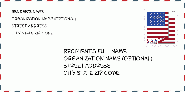
How to write a U.S. envelope?

-
First, you need to fill in the recipient's mailing information in the center of the envelope. The first line is the recipient's name, the second line is the street address with a detailed house number, and the last line is the city, state abbr, and ZIP Code.
Second, write the sender's information on the left top corner of the envelope. If your mail cannot be delivered, it will return to the sender's address.
Finally, don't forget to stick the stamp on the right top corner. Otherwise, the letter will not go into the delivery process.
Here is the envelope example below.
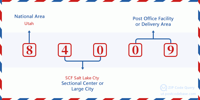
What does each digit of ZIP Code 84009 stand for?
-
The first digit designates a national area, which ranges from zero for the Northeast to nine for the far West.
The 2-3 digits represent a sectional center facility in that region.
The last two digits designate small post offices or postal zones.
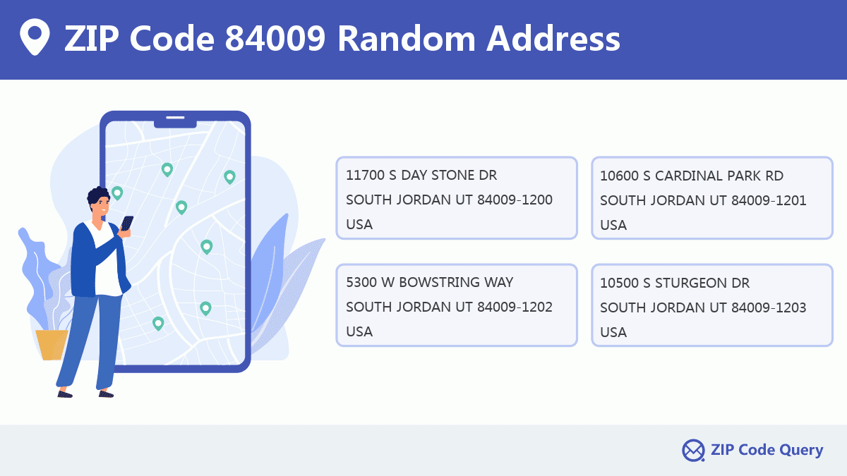
Random Address in ZIP 84009

ZIP Code 84009 has 2,904 real random addresses, you can clicking the picture below to get random addresses in ZIP Code 84009.
ZIP 84009 Online Map

This is online map of the address SOUTH JORDAN, Salt Lake County, Utah. You may use button to move and zoom in / out. The map information is for reference only.
ZIP 84009 NearBy ZIP Code
The Nearby ZIP Codes are 84095, 84081, 84088, 84096, and 84084, you can find ZIP codes in a 25km radius around ZIP Code 84009 and the approximate distance between the two ZIP codes.
The data has a slight deviation for your reference only.
| ZIP Code | Distance (Kilo Meters) |
|---|---|
| 84095 | 3.043 |
| 84081 | 5.287 |
| 84088 | 6.474 |
| 84096 | 7.881 |
| 84084 | 8.901 |
| 84065 | 9.502 |
| 84129 | 9.57 |
| 84006 | 9.788 |
| 84070 | 10.661 |
| 84118 | 10.854 |
| 84091 | 12.107 |
| 84090 | 12.199 |
| 84047 | 12.954 |
| 84094 | 13.248 |
| 84123 | 14.178 |
| 84020 | 14.306 |
| 84120 | 15.8 |
| 84128 | 15.881 |
| 84107 | 15.935 |
| 84157 | 16.58 |
| 84093 | 16.868 |
| 84119 | 17.083 |
| 84044 | 17.51 |
| 84092 | 18.311 |
| 84117 | 19.488 |
| 84115 | 20.587 |
| 84043 | 20.788 |
| 84106 | 21.736 |
| 84104 | 22.046 |
| 84003 | 23.091 |
| 84105 | 24.419 |
| 84101 | 24.474 |
| 84045 | 24.853 |

Comment


