Endereço: 600 (From 600 To 798 Even) N (North) 150 W (West), HURRICANE, UT 84737-1613, USA
O que é o 84737-1613? 84737-1613 é um número de CEP 5 Plus 4 de 600 (From 600 To 798 Even) N (North) 150 W (West), HURRICANE, UT, USA. Abaixo estão as informações detalhadas.
84737-1613 Informação básica

-
CEP 5 mais 4:
84737-1613 -
CEP 5:
84737 -
Mais 4?16134-digits that are used to identify a geographic segment within the 5-digit delivery area, such as a city block or a group of apartments or an individual high-volume receiver of mail, or any other unit that could use an extra identifier to aid in efficient mail sorting and delivery. This code is the low end of the range of +4 Codes that pertain to this ZIP Code. ZIP+4 Codes associated with nondelivery areas are composed of valid ZIP sector numbers and "ND" for the ZIP segment number, for example 12345-12ND. Non-deliverable areas are areas to which the USPS does not deliver mail, such as vacant lots and land that borders railroad tracks. Mailers should not match an address identified as a nondelivery area. If you absolutely must have numeric characters in the Plus4Code column, you may treat "ND" values as "00" (zero zero).:
-
País:
U.S. - United States -
Estado:
UT - Utah -
Condado:
CountyFIPS: 49053 - Washington County -
Cidade:
HURRICANE -
Street Predirectional:
N (North) -
Rua?150The official name of a street as assigned by a local governing authority. The Street Name column contains only the street name and does not include directionals (EAST, WEST, etc.) or suffixes (ST, DR, BLVD, etc.). This element may also contain literals, such as PO BOX, GENERAL DELIVERY, USS, PSC, or UNIT. Numeric street names that have numeric components that are four characters (or less) in length at are justified such that the low-order digit of the number is positioned in the fourth position of the street name column. This shift is made so that the numeric street names appear in numeric sequence.:
-
Rua Postdirecional?W (West)A geographic direction that precedes the street name. For Example: 472 MAIN ST N Street Pre-Direction Abbreviation = N Spaces = No pre-direction N = North NE = Northeast E = East SE = Southeast S = South SW = Southwest W = West NW = Northwest:
-
Tipo de Registro?S: RuaAn alphabetic value that identifies the type of data in the record. Record type codes include the following: G = General delivery H = Highrise F = Firm S = Street P = PO box R = Rural route/highway contract:
Endereço

- Endereço de número baixo primário?
A house, rural route, highway contract box, or post office box number; the numeric or alphanumeric component of an address preceding the street name; the low-end address in a range of addresses. Often referred to as house number.: 600
- Endereço Primário Número Alto?
A house, rural route, contract box, or Post Office box number. The numeric or alphanumeric component of an address preceding the street name. The high-end address in a range of addresses. Often referred to as house number.: 798
- Endereço do código ímpar / par primário?
Code that identifies the side or sides of a street for which a given address range is applicable. For street, highrise, firm and multi-carrier records, B = Both sides of a street, E = Even side of a street (even-numbered addresses in the range); O = Odd side of a street (odd-numbered addresses in the range). For general delivery, post office box, and rural route/highway contract records, this code will always be "B" (both).: Even
- Primário Faixa: 600, 602, 604, 606, 608, 610, 612, 614, 616, 618, 620, 622, 624, 626, 628, 630, 632, 634, 636, 638, 640, 642, 644, 646, 648, 650, 652, 654, 656, 658, 660, 662, 664, 666, 668, 670, 672, 674, 676, 678, 680, 682, 684, 686, 688, 690, 692, 694, 696, 698, 700, 702, 704, 706, 708, 710, 712, 714, 716, 718, 720, 722, 724, 726, 728, 730, 732, 734, 736, 738, 740, 742, 744, 746, 748, 750, 752, 754, 756, 758, 760, 762, 764, 766, 768, 770, 772, 774, 776, 778, 780, 782, 784, 786, 788, 790, 792, 794, 796, 798.
Clique no "Mais exemplos de endereços" para ver a lista completa.
600 N (North) 150 W (West), HURRICANE, UT 84737-1613
602 N (North) 150 W (West), HURRICANE, UT 84737-1613
604 N (North) 150 W (West), HURRICANE, UT 84737-1613
606 N (North) 150 W (West), HURRICANE, UT 84737-1613
608 N (North) 150 W (West), HURRICANE, UT 84737-1613
610 N (North) 150 W (West), HURRICANE, UT 84737-1613
612 N (North) 150 W (West), HURRICANE, UT 84737-1613
614 N (North) 150 W (West), HURRICANE, UT 84737-1613
616 N (North) 150 W (West), HURRICANE, UT 84737-1613
618 N (North) 150 W (West), HURRICANE, UT 84737-1613
620 N (North) 150 W (West), HURRICANE, UT 84737-1613
622 N (North) 150 W (West), HURRICANE, UT 84737-1613
624 N (North) 150 W (West), HURRICANE, UT 84737-1613
626 N (North) 150 W (West), HURRICANE, UT 84737-1613
628 N (North) 150 W (West), HURRICANE, UT 84737-1613
630 N (North) 150 W (West), HURRICANE, UT 84737-1613
632 N (North) 150 W (West), HURRICANE, UT 84737-1613
634 N (North) 150 W (West), HURRICANE, UT 84737-1613
636 N (North) 150 W (West), HURRICANE, UT 84737-1613
638 N (North) 150 W (West), HURRICANE, UT 84737-1613
640 N (North) 150 W (West), HURRICANE, UT 84737-1613
642 N (North) 150 W (West), HURRICANE, UT 84737-1613
644 N (North) 150 W (West), HURRICANE, UT 84737-1613
646 N (North) 150 W (West), HURRICANE, UT 84737-1613
648 N (North) 150 W (West), HURRICANE, UT 84737-1613
650 N (North) 150 W (West), HURRICANE, UT 84737-1613
652 N (North) 150 W (West), HURRICANE, UT 84737-1613
654 N (North) 150 W (West), HURRICANE, UT 84737-1613
656 N (North) 150 W (West), HURRICANE, UT 84737-1613
658 N (North) 150 W (West), HURRICANE, UT 84737-1613
660 N (North) 150 W (West), HURRICANE, UT 84737-1613
662 N (North) 150 W (West), HURRICANE, UT 84737-1613
664 N (North) 150 W (West), HURRICANE, UT 84737-1613
666 N (North) 150 W (West), HURRICANE, UT 84737-1613
668 N (North) 150 W (West), HURRICANE, UT 84737-1613
670 N (North) 150 W (West), HURRICANE, UT 84737-1613
672 N (North) 150 W (West), HURRICANE, UT 84737-1613
674 N (North) 150 W (West), HURRICANE, UT 84737-1613
676 N (North) 150 W (West), HURRICANE, UT 84737-1613
678 N (North) 150 W (West), HURRICANE, UT 84737-1613
680 N (North) 150 W (West), HURRICANE, UT 84737-1613
682 N (North) 150 W (West), HURRICANE, UT 84737-1613
684 N (North) 150 W (West), HURRICANE, UT 84737-1613
686 N (North) 150 W (West), HURRICANE, UT 84737-1613
688 N (North) 150 W (West), HURRICANE, UT 84737-1613
690 N (North) 150 W (West), HURRICANE, UT 84737-1613
692 N (North) 150 W (West), HURRICANE, UT 84737-1613
694 N (North) 150 W (West), HURRICANE, UT 84737-1613
696 N (North) 150 W (West), HURRICANE, UT 84737-1613
698 N (North) 150 W (West), HURRICANE, UT 84737-1613
700 N (North) 150 W (West), HURRICANE, UT 84737-1613
702 N (North) 150 W (West), HURRICANE, UT 84737-1613
704 N (North) 150 W (West), HURRICANE, UT 84737-1613
706 N (North) 150 W (West), HURRICANE, UT 84737-1613
708 N (North) 150 W (West), HURRICANE, UT 84737-1613
710 N (North) 150 W (West), HURRICANE, UT 84737-1613
712 N (North) 150 W (West), HURRICANE, UT 84737-1613
714 N (North) 150 W (West), HURRICANE, UT 84737-1613
716 N (North) 150 W (West), HURRICANE, UT 84737-1613
718 N (North) 150 W (West), HURRICANE, UT 84737-1613
720 N (North) 150 W (West), HURRICANE, UT 84737-1613
722 N (North) 150 W (West), HURRICANE, UT 84737-1613
724 N (North) 150 W (West), HURRICANE, UT 84737-1613
726 N (North) 150 W (West), HURRICANE, UT 84737-1613
728 N (North) 150 W (West), HURRICANE, UT 84737-1613
730 N (North) 150 W (West), HURRICANE, UT 84737-1613
732 N (North) 150 W (West), HURRICANE, UT 84737-1613
734 N (North) 150 W (West), HURRICANE, UT 84737-1613
736 N (North) 150 W (West), HURRICANE, UT 84737-1613
738 N (North) 150 W (West), HURRICANE, UT 84737-1613
740 N (North) 150 W (West), HURRICANE, UT 84737-1613
742 N (North) 150 W (West), HURRICANE, UT 84737-1613
744 N (North) 150 W (West), HURRICANE, UT 84737-1613
746 N (North) 150 W (West), HURRICANE, UT 84737-1613
748 N (North) 150 W (West), HURRICANE, UT 84737-1613
750 N (North) 150 W (West), HURRICANE, UT 84737-1613
752 N (North) 150 W (West), HURRICANE, UT 84737-1613
754 N (North) 150 W (West), HURRICANE, UT 84737-1613
756 N (North) 150 W (West), HURRICANE, UT 84737-1613
758 N (North) 150 W (West), HURRICANE, UT 84737-1613
760 N (North) 150 W (West), HURRICANE, UT 84737-1613
762 N (North) 150 W (West), HURRICANE, UT 84737-1613
764 N (North) 150 W (West), HURRICANE, UT 84737-1613
766 N (North) 150 W (West), HURRICANE, UT 84737-1613
768 N (North) 150 W (West), HURRICANE, UT 84737-1613
770 N (North) 150 W (West), HURRICANE, UT 84737-1613
772 N (North) 150 W (West), HURRICANE, UT 84737-1613
774 N (North) 150 W (West), HURRICANE, UT 84737-1613
776 N (North) 150 W (West), HURRICANE, UT 84737-1613
778 N (North) 150 W (West), HURRICANE, UT 84737-1613
780 N (North) 150 W (West), HURRICANE, UT 84737-1613
782 N (North) 150 W (West), HURRICANE, UT 84737-1613
784 N (North) 150 W (West), HURRICANE, UT 84737-1613
786 N (North) 150 W (West), HURRICANE, UT 84737-1613
788 N (North) 150 W (West), HURRICANE, UT 84737-1613
790 N (North) 150 W (West), HURRICANE, UT 84737-1613
792 N (North) 150 W (West), HURRICANE, UT 84737-1613
794 N (North) 150 W (West), HURRICANE, UT 84737-1613
796 N (North) 150 W (West), HURRICANE, UT 84737-1613
798 N (North) 150 W (West), HURRICANE, UT 84737-1613
Endereço Exemplo
HURRICANE UT 84737-1613
UNITED STATES OF AMERICA
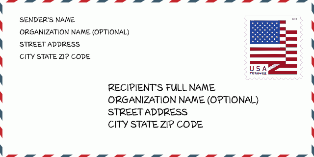
84737-1613 Exemplo de envelope

-
Este é um exemplo de envelope americano. Preencha as informações do remetente no canto superior esquerdo e as informações do destinatário no canto inferior direito. As informações necessárias são o nome completo do remetente / destinatário, endereço, cidade, estado e código postal. As informações do endereço do destinatário foram fornecidas para sua referência. Geralmente, se você não tiver certeza do código postal de 9 dígitos completo, só poderá preencher o código postal de 5 dígitos para evitar a perda do pacote.
84737-1613 Significado Básico
-
O que cada dígito do CEP 84737-1613 representa? O código ZIP + 4 consiste em duas partes, os primeiros cinco dígitos podem ser localizados na agência dos correios e os últimos quatro dígitos podem identificar um segmento geográfico dentro da área de entrega de cinco dígitos. Os 6 a 7 dígitos designam o setor ou vários blocos, e os 8 a 9 dígitos designam o segmento ou um lado de uma rua.
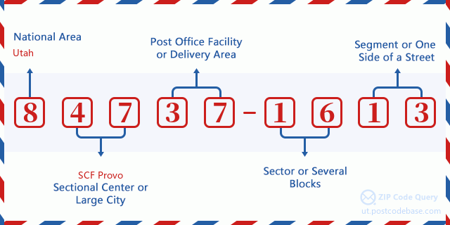

- ·ID da rota da transportadora?
A 4-digit code assigned to a mail delivery or collection route within a 5-digit ZIP Code. The first character of this identification is alphabetical, and the last three are numeric: Bnnn = PO box Hnnn = Highway contract Rnnn = Rural route Cnnn = City delivery Gnnn = General delivery: C001 (City delivery)
- ·Setor baixo do complemento ZIP?
The ZIP Add-On Low Sector and the ZIP Add-On Low Segment together form the ZIP Add-On Low Number. The ZIP Add-On Low Number is the last four positions of a ZIP+4 code; the low-end ZIP add-on in a range of codes; the add-on of the first ZIP+4 code in a consecutive series of ZIP+4 codes assigned to the delivery address. For example, most delivery addresses are assigned a single ZIP+4 code. However, large companies may be given a range of ZIP+4 codes that can be used to route mail to specific departments. A range of ZIP+4 codes can also be assigned to a corresponding range of post office boxes, and each box is mapped, one-to-one, with a ZIP+4 code in the range. A single post office box can also be assigned a range of ZIP+4 codes.: 16
- ·Segmento baixo do complemento ZIP?
The ZIP Add-On Low Sector and the ZIP Add-On Low Segment together form the ZIP Add-On Low Number. The ZIP Add-On Low Number is the last four positions of a ZIP+4 code; the low-end ZIP add-on in a range of codes; the add-on of the first ZIP+4 code in a consecutive series of ZIP+4 codes assigned to the delivery address. For example, most delivery addresses are assigned a single ZIP+4 code. However, large companies may be given a range of ZIP+4 codes that can be used to route mail to specific departments. A range of ZIP+4 codes can also be assigned to a corresponding range of post office boxes, and each box is mapped, one-to-one, with a ZIP+4 code in the range. A single post office box can also be assigned a range of ZIP+4 codes.: 13
- ·ZIP Add-On High Sector?
The ZIP Add-On High Sector and the ZIP Add-On High Segment together form the ZIP Add-On High Number, which is the high-end ZIP add-on in a range of codes; the add-on of the last ZIP+4 code in a consecutive series of ZIP+4 codes assigned to the delivery address. Most delivery addresses are assigned a single ZIP+4 code; however, large companies may be given a range of ZIP+4 codes that can be used to route mail to specific departments. A range of ZIP+4 codes can also be assigned to a corresponding range of post office boxes, and each box is mapped, one-to-one, with a ZIP+4 code in the range. A single post office box can also be assigned a range of ZIP+4 codes. (See also ZIP Add-On Code.): 16
- ·Complemento ZIP de alto segmento?
The ZIP Add-On High Sector and the ZIP Add-On High Segment together form the ZIP Add-On High Number, which is the high-end ZIP add-on in a range of codes; the add-on of the last ZIP+4 code in a consecutive series of ZIP+4 codes assigned to the delivery address. Most delivery addresses are assigned a single ZIP+4 code; however, large companies may be given a range of ZIP+4 codes that can be used to route mail to specific departments. A range of ZIP+4 codes can also be assigned to a corresponding range of post office boxes, and each box is mapped, one-to-one, with a ZIP+4 code in the range. A single post office box can also be assigned a range of ZIP+4 codes. (See also ZIP Add-On Code.): 13
- ·Código Postal Add On: 1613
- ·Faixa?
The range of +4 codes. Summing the +4 Code and the +4 Range will give you the high end of the range of +4 Codes that pertain to this ZIP Code.: 0
- ·Código Alternativo Básico?
Code that specifies whether a record is a base (preferred) or alternate record. Base records (represented as "B") can represent a range of addresses or an individual address, such as a firm record, while alternate records (represented as "A") are individual delivery points. Government deliveries will only be listed on alternate records with the appropriate government building indicator (federal, state, or city) set.: Base
- ·Número Financeiro?
A code assigned to Postal Service facilities (primarily post offices) to collect cost and statistical data and compile revenue and expense data. The state number comprises the first two positions of the finance number.: 493944
- ·Número do distrito congressional?
A standard value identifying a geographic area within the United States served by a member of the US House of Representatives or Senate. If Army/Air Force (APO) or fleet post office (FPO), this column will be blank. If there is only one member of Congress within a state, the code will be "AL" (at large).: 02
- ·Chave de estado da cidade de última linha preferida?
An index to the City State file that provides the preferred last-line name for this address range.: Z16063
Mapa Online

Este é o mapa on-line do endereço 600 N (North) 150 HURRICANE. Você pode usar o botão para mover e fazer zoom in / out. As informações do mapa são apenas para referência.
Endereço: 600 (From 600 To 798 Even) N (North) 150 W (West), HURRICANE, UT 84737-1613, USA
Comment


Add new comment