Adresse: 1700 (From 1700 To 1799) E (East) 1225 N (North), LAYTON, UT 84040-7834, USA
Qu'est-ce que 84040-7834? 84040-7834 est un code postal à 5 Plus 4 chiffres de 1700 (From 1700 To 1799) E (East) 1225 N (North), LAYTON, UT, USA. Les informations détaillées sont ci-dessous.
84040-7834 Informations de base

-
Code Postal 5 Plus 4:
84040-7834 -
Code Postal 5:
84040 -
Plus 4?78344-digits that are used to identify a geographic segment within the 5-digit delivery area, such as a city block or a group of apartments or an individual high-volume receiver of mail, or any other unit that could use an extra identifier to aid in efficient mail sorting and delivery. This code is the low end of the range of +4 Codes that pertain to this ZIP Code. ZIP+4 Codes associated with nondelivery areas are composed of valid ZIP sector numbers and "ND" for the ZIP segment number, for example 12345-12ND. Non-deliverable areas are areas to which the USPS does not deliver mail, such as vacant lots and land that borders railroad tracks. Mailers should not match an address identified as a nondelivery area. If you absolutely must have numeric characters in the Plus4Code column, you may treat "ND" values as "00" (zero zero).:
-
Pays:
U.S. - États-Unis -
État:
UT - Utah -
Comté:
CountyFIPS: 49011 - Davis County -
Ville:
LAYTON -
Rue Prédirectionnelle:
E (East) -
Rue?1225The official name of a street as assigned by a local governing authority. The Street Name column contains only the street name and does not include directionals (EAST, WEST, etc.) or suffixes (ST, DR, BLVD, etc.). This element may also contain literals, such as PO BOX, GENERAL DELIVERY, USS, PSC, or UNIT. Numeric street names that have numeric components that are four characters (or less) in length at are justified such that the low-order digit of the number is positioned in the fourth position of the street name column. This shift is made so that the numeric street names appear in numeric sequence.:
-
Rue Postdirectionnelle?N (North)A geographic direction that precedes the street name. For Example: 472 MAIN ST N Street Pre-Direction Abbreviation = N Spaces = No pre-direction N = North NE = Northeast E = East SE = Southeast S = South SW = Southwest W = West NW = Northwest:
-
Type d'enregistrement?S: RueAn alphabetic value that identifies the type of data in the record. Record type codes include the following: G = General delivery H = Highrise F = Firm S = Street P = PO box R = Rural route/highway contract:
Adresse

- Numéro Bas d'Adresse Primaire?
A house, rural route, highway contract box, or post office box number; the numeric or alphanumeric component of an address preceding the street name; the low-end address in a range of addresses. Often referred to as house number.: 1700
- Numéro Haut d'Adresse Primaire?
A house, rural route, contract box, or Post Office box number. The numeric or alphanumeric component of an address preceding the street name. The high-end address in a range of addresses. Often referred to as house number.: 1799
- Code Pair/Impair d'Adresse Primaire?
Code that identifies the side or sides of a street for which a given address range is applicable. For street, highrise, firm and multi-carrier records, B = Both sides of a street, E = Even side of a street (even-numbered addresses in the range); O = Odd side of a street (odd-numbered addresses in the range). For general delivery, post office box, and rural route/highway contract records, this code will always be "B" (both).: Both of Odd and Even
- Primaire Sphère: 1700, 1701, 1702, 1703, 1704, 1705, 1706, 1707, 1708, 1709, 1710, 1711, 1712, 1713, 1714, 1715, 1716, 1717, 1718, 1719, 1720, 1721, 1722, 1723, 1724, 1725, 1726, 1727, 1728, 1729, 1730, 1731, 1732, 1733, 1734, 1735, 1736, 1737, 1738, 1739, 1740, 1741, 1742, 1743, 1744, 1745, 1746, 1747, 1748, 1749, 1750, 1751, 1752, 1753, 1754, 1755, 1756, 1757, 1758, 1759, 1760, 1761, 1762, 1763, 1764, 1765, 1766, 1767, 1768, 1769, 1770, 1771, 1772, 1773, 1774, 1775, 1776, 1777, 1778, 1779, 1780, 1781, 1782, 1783, 1784, 1785, 1786, 1787, 1788, 1789, 1790, 1791, 1792, 1793, 1794, 1795, 1796, 1797, 1798, 1799.
Veuillez cliquer sur le "Plus d'exemples d'adresses" pour voir toute la liste.
1700 E (East) 1225 N (North), LAYTON, UT 84040-7834
1701 E (East) 1225 N (North), LAYTON, UT 84040-7834
1702 E (East) 1225 N (North), LAYTON, UT 84040-7834
1703 E (East) 1225 N (North), LAYTON, UT 84040-7834
1704 E (East) 1225 N (North), LAYTON, UT 84040-7834
1705 E (East) 1225 N (North), LAYTON, UT 84040-7834
1706 E (East) 1225 N (North), LAYTON, UT 84040-7834
1707 E (East) 1225 N (North), LAYTON, UT 84040-7834
1708 E (East) 1225 N (North), LAYTON, UT 84040-7834
1709 E (East) 1225 N (North), LAYTON, UT 84040-7834
1710 E (East) 1225 N (North), LAYTON, UT 84040-7834
1711 E (East) 1225 N (North), LAYTON, UT 84040-7834
1712 E (East) 1225 N (North), LAYTON, UT 84040-7834
1713 E (East) 1225 N (North), LAYTON, UT 84040-7834
1714 E (East) 1225 N (North), LAYTON, UT 84040-7834
1715 E (East) 1225 N (North), LAYTON, UT 84040-7834
1716 E (East) 1225 N (North), LAYTON, UT 84040-7834
1717 E (East) 1225 N (North), LAYTON, UT 84040-7834
1718 E (East) 1225 N (North), LAYTON, UT 84040-7834
1719 E (East) 1225 N (North), LAYTON, UT 84040-7834
1720 E (East) 1225 N (North), LAYTON, UT 84040-7834
1721 E (East) 1225 N (North), LAYTON, UT 84040-7834
1722 E (East) 1225 N (North), LAYTON, UT 84040-7834
1723 E (East) 1225 N (North), LAYTON, UT 84040-7834
1724 E (East) 1225 N (North), LAYTON, UT 84040-7834
1725 E (East) 1225 N (North), LAYTON, UT 84040-7834
1726 E (East) 1225 N (North), LAYTON, UT 84040-7834
1727 E (East) 1225 N (North), LAYTON, UT 84040-7834
1728 E (East) 1225 N (North), LAYTON, UT 84040-7834
1729 E (East) 1225 N (North), LAYTON, UT 84040-7834
1730 E (East) 1225 N (North), LAYTON, UT 84040-7834
1731 E (East) 1225 N (North), LAYTON, UT 84040-7834
1732 E (East) 1225 N (North), LAYTON, UT 84040-7834
1733 E (East) 1225 N (North), LAYTON, UT 84040-7834
1734 E (East) 1225 N (North), LAYTON, UT 84040-7834
1735 E (East) 1225 N (North), LAYTON, UT 84040-7834
1736 E (East) 1225 N (North), LAYTON, UT 84040-7834
1737 E (East) 1225 N (North), LAYTON, UT 84040-7834
1738 E (East) 1225 N (North), LAYTON, UT 84040-7834
1739 E (East) 1225 N (North), LAYTON, UT 84040-7834
1740 E (East) 1225 N (North), LAYTON, UT 84040-7834
1741 E (East) 1225 N (North), LAYTON, UT 84040-7834
1742 E (East) 1225 N (North), LAYTON, UT 84040-7834
1743 E (East) 1225 N (North), LAYTON, UT 84040-7834
1744 E (East) 1225 N (North), LAYTON, UT 84040-7834
1745 E (East) 1225 N (North), LAYTON, UT 84040-7834
1746 E (East) 1225 N (North), LAYTON, UT 84040-7834
1747 E (East) 1225 N (North), LAYTON, UT 84040-7834
1748 E (East) 1225 N (North), LAYTON, UT 84040-7834
1749 E (East) 1225 N (North), LAYTON, UT 84040-7834
1750 E (East) 1225 N (North), LAYTON, UT 84040-7834
1751 E (East) 1225 N (North), LAYTON, UT 84040-7834
1752 E (East) 1225 N (North), LAYTON, UT 84040-7834
1753 E (East) 1225 N (North), LAYTON, UT 84040-7834
1754 E (East) 1225 N (North), LAYTON, UT 84040-7834
1755 E (East) 1225 N (North), LAYTON, UT 84040-7834
1756 E (East) 1225 N (North), LAYTON, UT 84040-7834
1757 E (East) 1225 N (North), LAYTON, UT 84040-7834
1758 E (East) 1225 N (North), LAYTON, UT 84040-7834
1759 E (East) 1225 N (North), LAYTON, UT 84040-7834
1760 E (East) 1225 N (North), LAYTON, UT 84040-7834
1761 E (East) 1225 N (North), LAYTON, UT 84040-7834
1762 E (East) 1225 N (North), LAYTON, UT 84040-7834
1763 E (East) 1225 N (North), LAYTON, UT 84040-7834
1764 E (East) 1225 N (North), LAYTON, UT 84040-7834
1765 E (East) 1225 N (North), LAYTON, UT 84040-7834
1766 E (East) 1225 N (North), LAYTON, UT 84040-7834
1767 E (East) 1225 N (North), LAYTON, UT 84040-7834
1768 E (East) 1225 N (North), LAYTON, UT 84040-7834
1769 E (East) 1225 N (North), LAYTON, UT 84040-7834
1770 E (East) 1225 N (North), LAYTON, UT 84040-7834
1771 E (East) 1225 N (North), LAYTON, UT 84040-7834
1772 E (East) 1225 N (North), LAYTON, UT 84040-7834
1773 E (East) 1225 N (North), LAYTON, UT 84040-7834
1774 E (East) 1225 N (North), LAYTON, UT 84040-7834
1775 E (East) 1225 N (North), LAYTON, UT 84040-7834
1776 E (East) 1225 N (North), LAYTON, UT 84040-7834
1777 E (East) 1225 N (North), LAYTON, UT 84040-7834
1778 E (East) 1225 N (North), LAYTON, UT 84040-7834
1779 E (East) 1225 N (North), LAYTON, UT 84040-7834
1780 E (East) 1225 N (North), LAYTON, UT 84040-7834
1781 E (East) 1225 N (North), LAYTON, UT 84040-7834
1782 E (East) 1225 N (North), LAYTON, UT 84040-7834
1783 E (East) 1225 N (North), LAYTON, UT 84040-7834
1784 E (East) 1225 N (North), LAYTON, UT 84040-7834
1785 E (East) 1225 N (North), LAYTON, UT 84040-7834
1786 E (East) 1225 N (North), LAYTON, UT 84040-7834
1787 E (East) 1225 N (North), LAYTON, UT 84040-7834
1788 E (East) 1225 N (North), LAYTON, UT 84040-7834
1789 E (East) 1225 N (North), LAYTON, UT 84040-7834
1790 E (East) 1225 N (North), LAYTON, UT 84040-7834
1791 E (East) 1225 N (North), LAYTON, UT 84040-7834
1792 E (East) 1225 N (North), LAYTON, UT 84040-7834
1793 E (East) 1225 N (North), LAYTON, UT 84040-7834
1794 E (East) 1225 N (North), LAYTON, UT 84040-7834
1795 E (East) 1225 N (North), LAYTON, UT 84040-7834
1796 E (East) 1225 N (North), LAYTON, UT 84040-7834
1797 E (East) 1225 N (North), LAYTON, UT 84040-7834
1798 E (East) 1225 N (North), LAYTON, UT 84040-7834
1799 E (East) 1225 N (North), LAYTON, UT 84040-7834
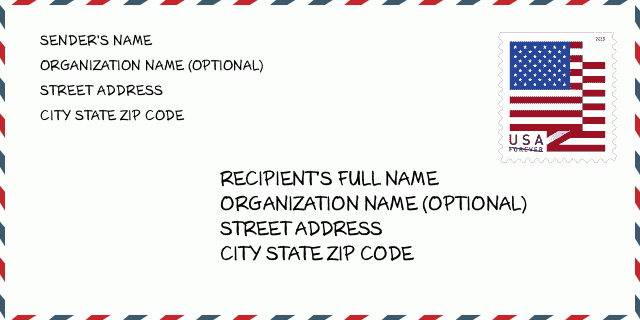
Adresse Exemple
LAYTON UT 84040-7834
UNITED STATES OF AMERICA
84040-7834 Exemple d'Enveloppe

-
This is an example of U.S envelope. Fill in the sender's information at the top left and the recipient information at the bottom right. The necessary information is sender/recipient's full name, street address, city, state and zip code. The recipient address information has been given for your reference. Generally, If you are not sure of the full 9-digit zip code, you can only fill in the 5-digit zip code to avoid loss of package.
84040-7834 Signification de base
-
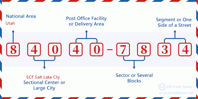
Que signifie chaque chiffre du code postal 84040-7834 ? Le code postal + 4 se compose de deux parties, les cinq premiers chiffres peuvent être localisés au bureau de poste et les quatre derniers chiffres peuvent identifier un segment géographique dans la zone de livraison à cinq chiffres. Les 6-7 chiffres désignent un secteur ou plusieurs blocs, et les 8-9 chiffres désignent un segment ou un côté d'une rue.

- ·ID de Route de Transport?
A 4-digit code assigned to a mail delivery or collection route within a 5-digit ZIP Code. The first character of this identification is alphabetical, and the last three are numeric: Bnnn = PO box Hnnn = Highway contract Rnnn = Rural route Cnnn = City delivery Gnnn = General delivery: R005 (Route Rurale)
- ·Secteur Bas Additif Postal?
The ZIP Add-On Low Sector and the ZIP Add-On Low Segment together form the ZIP Add-On Low Number. The ZIP Add-On Low Number is the last four positions of a ZIP+4 code; the low-end ZIP add-on in a range of codes; the add-on of the first ZIP+4 code in a consecutive series of ZIP+4 codes assigned to the delivery address. For example, most delivery addresses are assigned a single ZIP+4 code. However, large companies may be given a range of ZIP+4 codes that can be used to route mail to specific departments. A range of ZIP+4 codes can also be assigned to a corresponding range of post office boxes, and each box is mapped, one-to-one, with a ZIP+4 code in the range. A single post office box can also be assigned a range of ZIP+4 codes.: 78
- ·Segment Bas Additif Postal?
The ZIP Add-On Low Sector and the ZIP Add-On Low Segment together form the ZIP Add-On Low Number. The ZIP Add-On Low Number is the last four positions of a ZIP+4 code; the low-end ZIP add-on in a range of codes; the add-on of the first ZIP+4 code in a consecutive series of ZIP+4 codes assigned to the delivery address. For example, most delivery addresses are assigned a single ZIP+4 code. However, large companies may be given a range of ZIP+4 codes that can be used to route mail to specific departments. A range of ZIP+4 codes can also be assigned to a corresponding range of post office boxes, and each box is mapped, one-to-one, with a ZIP+4 code in the range. A single post office box can also be assigned a range of ZIP+4 codes.: 34
- ·Secteur Haut d'Expansion Postal?
The ZIP Add-On High Sector and the ZIP Add-On High Segment together form the ZIP Add-On High Number, which is the high-end ZIP add-on in a range of codes; the add-on of the last ZIP+4 code in a consecutive series of ZIP+4 codes assigned to the delivery address. Most delivery addresses are assigned a single ZIP+4 code; however, large companies may be given a range of ZIP+4 codes that can be used to route mail to specific departments. A range of ZIP+4 codes can also be assigned to a corresponding range of post office boxes, and each box is mapped, one-to-one, with a ZIP+4 code in the range. A single post office box can also be assigned a range of ZIP+4 codes. (See also ZIP Add-On Code.): 78
- ·Segment Haut d'Expansion Postal?
The ZIP Add-On High Sector and the ZIP Add-On High Segment together form the ZIP Add-On High Number, which is the high-end ZIP add-on in a range of codes; the add-on of the last ZIP+4 code in a consecutive series of ZIP+4 codes assigned to the delivery address. Most delivery addresses are assigned a single ZIP+4 code; however, large companies may be given a range of ZIP+4 codes that can be used to route mail to specific departments. A range of ZIP+4 codes can also be assigned to a corresponding range of post office boxes, and each box is mapped, one-to-one, with a ZIP+4 code in the range. A single post office box can also be assigned a range of ZIP+4 codes. (See also ZIP Add-On Code.): 34
- ·Code Postal Ajouter sur: 7834
- ·Sphère?
The range of +4 codes. Summing the +4 Code and the +4 Range will give you the high end of the range of +4 Codes that pertain to this ZIP Code.: 0
- ·Code Alternatif de Base?
Code that specifies whether a record is a base (preferred) or alternate record. Base records (represented as "B") can represent a range of addresses or an individual address, such as a firm record, while alternate records (represented as "A") are individual delivery points. Government deliveries will only be listed on alternate records with the appropriate government building indicator (federal, state, or city) set.: Base
- ·Numéro de Finance?
A code assigned to Postal Service facilities (primarily post offices) to collect cost and statistical data and compile revenue and expense data. The state number comprises the first two positions of the finance number.: 494760
- ·Numéro de District de Congrès?
A standard value identifying a geographic area within the United States served by a member of the US House of Representatives or Senate. If Army/Air Force (APO) or fleet post office (FPO), this column will be blank. If there is only one member of Congress within a state, the code will be "AL" (at large).: 01
- ·Clé d'Etat de Ville de Dernière Ligne Préférée?
An index to the City State file that provides the preferred last-line name for this address range.: Z16101
Carte en ligne

C'est la carte en ligne d'adresse 1700 E (East) 1225 LAYTON. Vous pouvez utiliser le bouton pour déplacer et zoomer / dézoomer. Les informations de la carte est seulement pour référence.
Adresse: 1700 (From 1700 To 1799) E (East) 1225 N (North), LAYTON, UT 84040-7834, USA
Commentaire


Ajouter un commentaire