Dirección: 1000 (From 1000 To 1099) N (North) 540 W (West), AMERICAN FORK, UT 84003-1111, USA
¿Qué es 84003-1111? 84003-1111 es un Cógido Postal 5 Más 4 de 1000 (From 1000 To 1099) N (North) 540 W (West), AMERICAN FORK, UT, USA. La información detallada se muestra abajo.
84003-1111 Información básica

-
Código Postal 5 Más 4:
84003-1111 -
Código Postal 5:
84003 -
Plus 4?11114-digits that are used to identify a geographic segment within the 5-digit delivery area, such as a city block or a group of apartments or an individual high-volume receiver of mail, or any other unit that could use an extra identifier to aid in efficient mail sorting and delivery. This code is the low end of the range of +4 Codes that pertain to this ZIP Code. ZIP+4 Codes associated with nondelivery areas are composed of valid ZIP sector numbers and "ND" for the ZIP segment number, for example 12345-12ND. Non-deliverable areas are areas to which the USPS does not deliver mail, such as vacant lots and land that borders railroad tracks. Mailers should not match an address identified as a nondelivery area. If you absolutely must have numeric characters in the Plus4Code column, you may treat "ND" values as "00" (zero zero).:
-
País:
U.S. - Estados Unidos -
Estado:
UT - Utah -
Condado:
CountyFIPS: 49049 - Utah County -
Ciudad:
AMERICAN FORK -
Predireccional de Calle:
N (North) -
Calle?540The official name of a street as assigned by a local governing authority. The Street Name column contains only the street name and does not include directionals (EAST, WEST, etc.) or suffixes (ST, DR, BLVD, etc.). This element may also contain literals, such as PO BOX, GENERAL DELIVERY, USS, PSC, or UNIT. Numeric street names that have numeric components that are four characters (or less) in length at are justified such that the low-order digit of the number is positioned in the fourth position of the street name column. This shift is made so that the numeric street names appear in numeric sequence.:
-
Postdireccional de Calle?W (West)A geographic direction that precedes the street name. For Example: 472 MAIN ST N Street Pre-Direction Abbreviation = N Spaces = No pre-direction N = North NE = Northeast E = East SE = Southeast S = South SW = Southwest W = West NW = Northwest:
-
Tipo de Registro?S: CalleAn alphabetic value that identifies the type of data in the record. Record type codes include the following: G = General delivery H = Highrise F = Firm S = Street P = PO box R = Rural route/highway contract:
Dirección

- Número Bajo Primario de Dirección?
A house, rural route, highway contract box, or post office box number; the numeric or alphanumeric component of an address preceding the street name; the low-end address in a range of addresses. Often referred to as house number.: 1000
- Número Alto Primario de Dirección?
A house, rural route, contract box, or Post Office box number. The numeric or alphanumeric component of an address preceding the street name. The high-end address in a range of addresses. Often referred to as house number.: 1099
- Código Impar / Par Primario de Dirección?
Code that identifies the side or sides of a street for which a given address range is applicable. For street, highrise, firm and multi-carrier records, B = Both sides of a street, E = Even side of a street (even-numbered addresses in the range); O = Odd side of a street (odd-numbered addresses in the range). For general delivery, post office box, and rural route/highway contract records, this code will always be "B" (both).: Both of Odd and Even
- Primario Alcance: 1000, 1001, 1002, 1003, 1004, 1005, 1006, 1007, 1008, 1009, 1010, 1011, 1012, 1013, 1014, 1015, 1016, 1017, 1018, 1019, 1020, 1021, 1022, 1023, 1024, 1025, 1026, 1027, 1028, 1029, 1030, 1031, 1032, 1033, 1034, 1035, 1036, 1037, 1038, 1039, 1040, 1041, 1042, 1043, 1044, 1045, 1046, 1047, 1048, 1049, 1050, 1051, 1052, 1053, 1054, 1055, 1056, 1057, 1058, 1059, 1060, 1061, 1062, 1063, 1064, 1065, 1066, 1067, 1068, 1069, 1070, 1071, 1072, 1073, 1074, 1075, 1076, 1077, 1078, 1079, 1080, 1081, 1082, 1083, 1084, 1085, 1086, 1087, 1088, 1089, 1090, 1091, 1092, 1093, 1094, 1095, 1096, 1097, 1098, 1099.
Haga clic en "Más ejemplos de direcciones" para ver la lista completa.
1000 N (North) 540 W (West), AMERICAN FORK, UT 84003-1111
1001 N (North) 540 W (West), AMERICAN FORK, UT 84003-1111
1002 N (North) 540 W (West), AMERICAN FORK, UT 84003-1111
1003 N (North) 540 W (West), AMERICAN FORK, UT 84003-1111
1004 N (North) 540 W (West), AMERICAN FORK, UT 84003-1111
1005 N (North) 540 W (West), AMERICAN FORK, UT 84003-1111
1006 N (North) 540 W (West), AMERICAN FORK, UT 84003-1111
1007 N (North) 540 W (West), AMERICAN FORK, UT 84003-1111
1008 N (North) 540 W (West), AMERICAN FORK, UT 84003-1111
1009 N (North) 540 W (West), AMERICAN FORK, UT 84003-1111
1010 N (North) 540 W (West), AMERICAN FORK, UT 84003-1111
1011 N (North) 540 W (West), AMERICAN FORK, UT 84003-1111
1012 N (North) 540 W (West), AMERICAN FORK, UT 84003-1111
1013 N (North) 540 W (West), AMERICAN FORK, UT 84003-1111
1014 N (North) 540 W (West), AMERICAN FORK, UT 84003-1111
1015 N (North) 540 W (West), AMERICAN FORK, UT 84003-1111
1016 N (North) 540 W (West), AMERICAN FORK, UT 84003-1111
1017 N (North) 540 W (West), AMERICAN FORK, UT 84003-1111
1018 N (North) 540 W (West), AMERICAN FORK, UT 84003-1111
1019 N (North) 540 W (West), AMERICAN FORK, UT 84003-1111
1020 N (North) 540 W (West), AMERICAN FORK, UT 84003-1111
1021 N (North) 540 W (West), AMERICAN FORK, UT 84003-1111
1022 N (North) 540 W (West), AMERICAN FORK, UT 84003-1111
1023 N (North) 540 W (West), AMERICAN FORK, UT 84003-1111
1024 N (North) 540 W (West), AMERICAN FORK, UT 84003-1111
1025 N (North) 540 W (West), AMERICAN FORK, UT 84003-1111
1026 N (North) 540 W (West), AMERICAN FORK, UT 84003-1111
1027 N (North) 540 W (West), AMERICAN FORK, UT 84003-1111
1028 N (North) 540 W (West), AMERICAN FORK, UT 84003-1111
1029 N (North) 540 W (West), AMERICAN FORK, UT 84003-1111
1030 N (North) 540 W (West), AMERICAN FORK, UT 84003-1111
1031 N (North) 540 W (West), AMERICAN FORK, UT 84003-1111
1032 N (North) 540 W (West), AMERICAN FORK, UT 84003-1111
1033 N (North) 540 W (West), AMERICAN FORK, UT 84003-1111
1034 N (North) 540 W (West), AMERICAN FORK, UT 84003-1111
1035 N (North) 540 W (West), AMERICAN FORK, UT 84003-1111
1036 N (North) 540 W (West), AMERICAN FORK, UT 84003-1111
1037 N (North) 540 W (West), AMERICAN FORK, UT 84003-1111
1038 N (North) 540 W (West), AMERICAN FORK, UT 84003-1111
1039 N (North) 540 W (West), AMERICAN FORK, UT 84003-1111
1040 N (North) 540 W (West), AMERICAN FORK, UT 84003-1111
1041 N (North) 540 W (West), AMERICAN FORK, UT 84003-1111
1042 N (North) 540 W (West), AMERICAN FORK, UT 84003-1111
1043 N (North) 540 W (West), AMERICAN FORK, UT 84003-1111
1044 N (North) 540 W (West), AMERICAN FORK, UT 84003-1111
1045 N (North) 540 W (West), AMERICAN FORK, UT 84003-1111
1046 N (North) 540 W (West), AMERICAN FORK, UT 84003-1111
1047 N (North) 540 W (West), AMERICAN FORK, UT 84003-1111
1048 N (North) 540 W (West), AMERICAN FORK, UT 84003-1111
1049 N (North) 540 W (West), AMERICAN FORK, UT 84003-1111
1050 N (North) 540 W (West), AMERICAN FORK, UT 84003-1111
1051 N (North) 540 W (West), AMERICAN FORK, UT 84003-1111
1052 N (North) 540 W (West), AMERICAN FORK, UT 84003-1111
1053 N (North) 540 W (West), AMERICAN FORK, UT 84003-1111
1054 N (North) 540 W (West), AMERICAN FORK, UT 84003-1111
1055 N (North) 540 W (West), AMERICAN FORK, UT 84003-1111
1056 N (North) 540 W (West), AMERICAN FORK, UT 84003-1111
1057 N (North) 540 W (West), AMERICAN FORK, UT 84003-1111
1058 N (North) 540 W (West), AMERICAN FORK, UT 84003-1111
1059 N (North) 540 W (West), AMERICAN FORK, UT 84003-1111
1060 N (North) 540 W (West), AMERICAN FORK, UT 84003-1111
1061 N (North) 540 W (West), AMERICAN FORK, UT 84003-1111
1062 N (North) 540 W (West), AMERICAN FORK, UT 84003-1111
1063 N (North) 540 W (West), AMERICAN FORK, UT 84003-1111
1064 N (North) 540 W (West), AMERICAN FORK, UT 84003-1111
1065 N (North) 540 W (West), AMERICAN FORK, UT 84003-1111
1066 N (North) 540 W (West), AMERICAN FORK, UT 84003-1111
1067 N (North) 540 W (West), AMERICAN FORK, UT 84003-1111
1068 N (North) 540 W (West), AMERICAN FORK, UT 84003-1111
1069 N (North) 540 W (West), AMERICAN FORK, UT 84003-1111
1070 N (North) 540 W (West), AMERICAN FORK, UT 84003-1111
1071 N (North) 540 W (West), AMERICAN FORK, UT 84003-1111
1072 N (North) 540 W (West), AMERICAN FORK, UT 84003-1111
1073 N (North) 540 W (West), AMERICAN FORK, UT 84003-1111
1074 N (North) 540 W (West), AMERICAN FORK, UT 84003-1111
1075 N (North) 540 W (West), AMERICAN FORK, UT 84003-1111
1076 N (North) 540 W (West), AMERICAN FORK, UT 84003-1111
1077 N (North) 540 W (West), AMERICAN FORK, UT 84003-1111
1078 N (North) 540 W (West), AMERICAN FORK, UT 84003-1111
1079 N (North) 540 W (West), AMERICAN FORK, UT 84003-1111
1080 N (North) 540 W (West), AMERICAN FORK, UT 84003-1111
1081 N (North) 540 W (West), AMERICAN FORK, UT 84003-1111
1082 N (North) 540 W (West), AMERICAN FORK, UT 84003-1111
1083 N (North) 540 W (West), AMERICAN FORK, UT 84003-1111
1084 N (North) 540 W (West), AMERICAN FORK, UT 84003-1111
1085 N (North) 540 W (West), AMERICAN FORK, UT 84003-1111
1086 N (North) 540 W (West), AMERICAN FORK, UT 84003-1111
1087 N (North) 540 W (West), AMERICAN FORK, UT 84003-1111
1088 N (North) 540 W (West), AMERICAN FORK, UT 84003-1111
1089 N (North) 540 W (West), AMERICAN FORK, UT 84003-1111
1090 N (North) 540 W (West), AMERICAN FORK, UT 84003-1111
1091 N (North) 540 W (West), AMERICAN FORK, UT 84003-1111
1092 N (North) 540 W (West), AMERICAN FORK, UT 84003-1111
1093 N (North) 540 W (West), AMERICAN FORK, UT 84003-1111
1094 N (North) 540 W (West), AMERICAN FORK, UT 84003-1111
1095 N (North) 540 W (West), AMERICAN FORK, UT 84003-1111
1096 N (North) 540 W (West), AMERICAN FORK, UT 84003-1111
1097 N (North) 540 W (West), AMERICAN FORK, UT 84003-1111
1098 N (North) 540 W (West), AMERICAN FORK, UT 84003-1111
1099 N (North) 540 W (West), AMERICAN FORK, UT 84003-1111
Dirección Ejemplo
AMERICAN FORK UT 84003-1111
UNITED STATES OF AMERICA
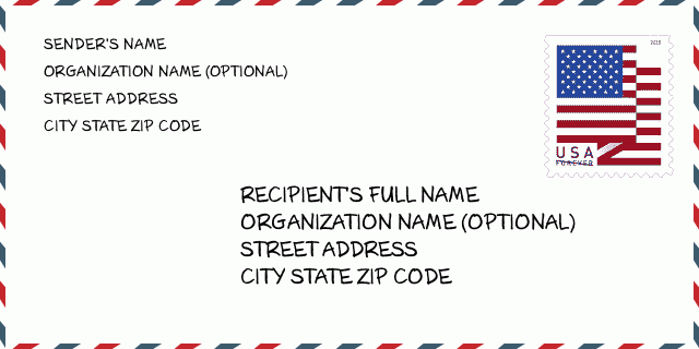
84003-1111 Ejemplo de Sobre

-
Este es un ejemplo de sobre estadounidense. Complete la información del remitente en la parte superior izquierda y la información del destinatario en la parte inferior derecha. La información necesaria es el nombre completo del remitente / destinatario, la dirección postal, la ciudad, el estado y el código postal. La información de la dirección del destinatario se ha proporcionado para su referencia. Generalmente, si no está seguro del código postal completo de 9 dígitos, solo puede completar el código postal de 5 dígitos para evitar la pérdida del paquete.
84003-1111 Significado básico
-
¿Qué significa cada dígito del código postal 84003-1111? El código postal + 4 consta de dos partes, los primeros cinco dígitos se pueden ubicar en la oficina postal y los últimos cuatro dígitos pueden identificar un segmento geográfico dentro del área de entrega de cinco dígitos. Los 6-7 dígitos designan un sector o varios bloques, y los 8-9 dígitos designan un segmento o un lado de una calle.
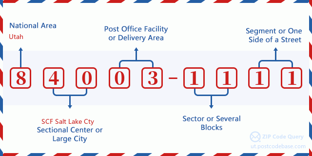

- ·ID de Ruta de Transportador?
A 4-digit code assigned to a mail delivery or collection route within a 5-digit ZIP Code. The first character of this identification is alphabetical, and the last three are numeric: Bnnn = PO box Hnnn = Highway contract Rnnn = Rural route Cnnn = City delivery Gnnn = General delivery: C001 (Entrega Urbana)
- ·Sector Bajo de Agregar Código Postal?
The ZIP Add-On Low Sector and the ZIP Add-On Low Segment together form the ZIP Add-On Low Number. The ZIP Add-On Low Number is the last four positions of a ZIP+4 code; the low-end ZIP add-on in a range of codes; the add-on of the first ZIP+4 code in a consecutive series of ZIP+4 codes assigned to the delivery address. For example, most delivery addresses are assigned a single ZIP+4 code. However, large companies may be given a range of ZIP+4 codes that can be used to route mail to specific departments. A range of ZIP+4 codes can also be assigned to a corresponding range of post office boxes, and each box is mapped, one-to-one, with a ZIP+4 code in the range. A single post office box can also be assigned a range of ZIP+4 codes.: 11
- ·Segmento Bajo de Agregar Código Postal?
The ZIP Add-On Low Sector and the ZIP Add-On Low Segment together form the ZIP Add-On Low Number. The ZIP Add-On Low Number is the last four positions of a ZIP+4 code; the low-end ZIP add-on in a range of codes; the add-on of the first ZIP+4 code in a consecutive series of ZIP+4 codes assigned to the delivery address. For example, most delivery addresses are assigned a single ZIP+4 code. However, large companies may be given a range of ZIP+4 codes that can be used to route mail to specific departments. A range of ZIP+4 codes can also be assigned to a corresponding range of post office boxes, and each box is mapped, one-to-one, with a ZIP+4 code in the range. A single post office box can also be assigned a range of ZIP+4 codes.: 11
- ·Sector Alto de Agregar Código Postal?
The ZIP Add-On High Sector and the ZIP Add-On High Segment together form the ZIP Add-On High Number, which is the high-end ZIP add-on in a range of codes; the add-on of the last ZIP+4 code in a consecutive series of ZIP+4 codes assigned to the delivery address. Most delivery addresses are assigned a single ZIP+4 code; however, large companies may be given a range of ZIP+4 codes that can be used to route mail to specific departments. A range of ZIP+4 codes can also be assigned to a corresponding range of post office boxes, and each box is mapped, one-to-one, with a ZIP+4 code in the range. A single post office box can also be assigned a range of ZIP+4 codes. (See also ZIP Add-On Code.): 11
- ·Segmento Alto de Agregar Código Postal?
The ZIP Add-On High Sector and the ZIP Add-On High Segment together form the ZIP Add-On High Number, which is the high-end ZIP add-on in a range of codes; the add-on of the last ZIP+4 code in a consecutive series of ZIP+4 codes assigned to the delivery address. Most delivery addresses are assigned a single ZIP+4 code; however, large companies may be given a range of ZIP+4 codes that can be used to route mail to specific departments. A range of ZIP+4 codes can also be assigned to a corresponding range of post office boxes, and each box is mapped, one-to-one, with a ZIP+4 code in the range. A single post office box can also be assigned a range of ZIP+4 codes. (See also ZIP Add-On Code.): 11
- ·Código Postal Añadir: 1111
- ·Alcance?
The range of +4 codes. Summing the +4 Code and the +4 Range will give you the high end of the range of +4 Codes that pertain to this ZIP Code.: 0
- ·Código Alternativo de Base?
Code that specifies whether a record is a base (preferred) or alternate record. Base records (represented as "B") can represent a range of addresses or an individual address, such as a firm record, while alternate records (represented as "A") are individual delivery points. Government deliveries will only be listed on alternate records with the appropriate government building indicator (federal, state, or city) set.: Base
- ·Número Financiero?
A code assigned to Postal Service facilities (primarily post offices) to collect cost and statistical data and compile revenue and expense data. The state number comprises the first two positions of the finance number.: 490170
- ·Número de Distrito del Congreso?
A standard value identifying a geographic area within the United States served by a member of the US House of Representatives or Senate. If Army/Air Force (APO) or fleet post office (FPO), this column will be blank. If there is only one member of Congress within a state, the code will be "AL" (at large).: 03
- ·Código de Estado de Ciudad de Línea Preferida?
An index to the City State file that provides the preferred last-line name for this address range.: Z15789
Mapa en Línea

Esto es el mapa en línea de la dirección 1000 N (North) 540 AMERICAN FORK. Podría utilizar el botón para moverse y acercarse / alejarse. La información del mapa sirve sólo como referencia.
Dirección: 1000 (From 1000 To 1099) N (North) 540 W (West), AMERICAN FORK, UT 84003-1111, USA
Comentario


Añadir nuevo comentario